By David (Jonah) Western

A report to the governor of Kajiado and the Amboseli Transition Team

The extensive flooding in March of 2026 caused the closure of the Amboseli airstrip. The flooding was the most extensive since the 2020, though not as severe. The 2020 floods shut down air traffic for weeks, inundated Ol Tukai Lodge and drowned tourist circuits. The damage caused heavy losses to tour operators and hoteliers and costs to KWS in road repairs. In response to the disruptions, Ol Tukai Lodge called an emergency meeting of KWS, hoteliers and conservation organizations to assess the damage. The Amboseli Conservation Programme was I was asked report on the cause of the flooding and remedial action.

The report below concluded that the ultimate cause of the extreme flooding is the growth of farms and permanent pastoral settlements around the national park. Regular seasonal flooding, starting in 1992, has created a permanent flamingo lake in the centre of the park. The more immediate cause of flooding is the Namanga and Sultan Hamud roads blocking flash flooding along the natural drainage channels into Lake Amboseli.

The report concluded a permanent solution to the flooding lay widening the drainage channels across the two roads to allow the storm water to flow into Lake Amboseli. In the short term, the report recommended widening the drainage channels under the Namanga Road and deepening the natural trough leading into Simek Swamp to lessen the flooding.

The hoteliers, led by Ol Tukai, raised 900,000/= for KWS to undertake the short-term drainage works. KWS had no funds of its own to fuel the excavator to dig the trench. The excavations did alleviate extreme flooding until the prolonged heavy rains of 2026. Then, a week of heavy rains, followed by a 100 mm storm, overwhelmed the capacity of the ditching. Had KWS widened the two roads blocking the natural flow of water into Lake Amboseli, the extreme floods would have been prevented.

The technical Committee appointed to prepare a vision and strategy for Kajiado County to manage Amboseli raised concerns over the flooding in its 2024 report. The report urged the drainage channels on the Sultan Hamud and Namanga Roads be widened to avoid the extreme flooding. No action was taken by KWS for lack of funds allocated to undertake the task.

The two earlier reports on the Amboseli flooding are attached as background to the following report.


Report on extensive flooding in March 2026

H.E Governor Joseph Ole Lenku asked me to take stock of the March flooding and report back on preventative measures. I flew down to Amboseli on 24th of March to record the flooding from the air. The following photos give a visual presentation of the floods.
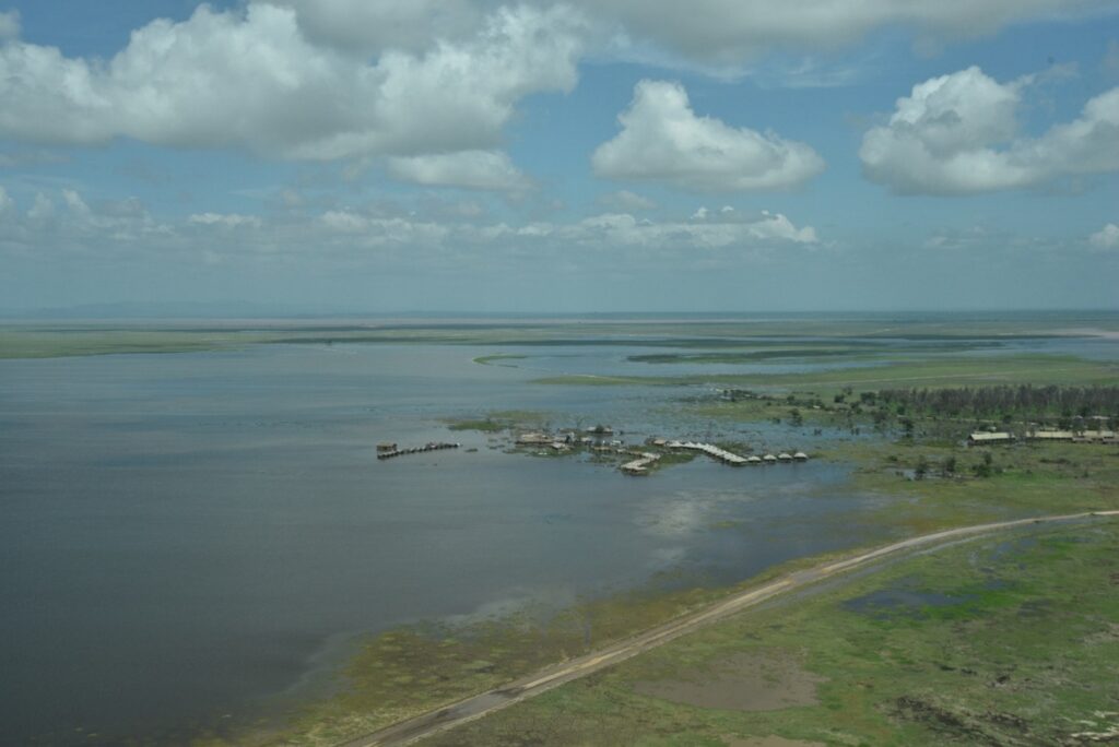
The Amboseli floods seen from Ol Tukai. The floods extended from the Kimana Road (foreground) to the airstrip seen at the far edge of the flooding. Lake Amboseli, the lowest point and drainage sump of Amboseli, is the red ribbon on the horizons.
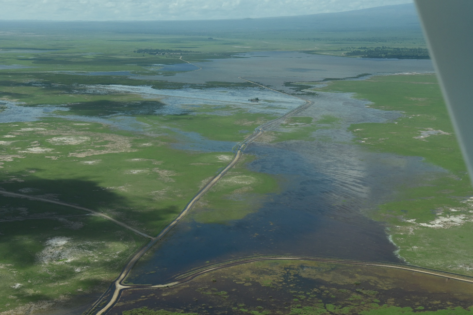
The flooding seen from west of the airstrip looking towards Ol Tukai. Note the large flooded area between the airstrip and Ol Tukai. The area has become a permanent flamingo lake since 1992. The excess flood waters from the flamingo lake now drain into the central basin, drowning the airstrip and tourist circuits during heavy rains.


Observations

The flash flooding in March stretched across the central portion of Amboseli National Park from the airstrip to Ol Tukai. Lengthy sections of tourist circuits around Longinye Swamp and the airstrip were submerged. Most of the drowned roads lie well below the ground surface due to continuous grading without any replacement murram to build them up again. The airstrip was also submerged but was serviceable by the time I flew down on 24th March. The roads to the airstrip were, however, under water, making it impossible for tourist vehicles to reach the airstrip.

The March flooding was extensive but far less so than in 2020. The airstrip drained within ten days rather than the weeks under water in 2020 floods. The rapid drainage was due to large part to the temporary KWS ditching siphoning off much of the flood waters into Lake Kioko and on to Lake Amboseli.

The cause of flooding

The ultimate cause of the extreme flooding results from the heavy permanent settlement on the higher ground surrounding the Amboseli Basin and national park. The worst floods cascade down the lower slopes of Kilimanjaro south of Namalog and flow through Kalunyet into Longinye Swamp, as seen in the photo below.
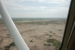
Erosion and flooding caused by heavy settlement on the lower slopes of Kilimanjaro has created a seasonal stream flowing into Longinye Swamp through Kalunyet in the eastern section of Amboseli National Park.

The flood waters flowing into Longinye would naturally drain into the Lake Amboseli along a series of shallow troughs. The natural flow has been blocked by the elevated Sultan Hamud and Namanga Roads damming the natural flow. The damming has widened Longinye Swamp nearly twice its former width. The widening has drowned tourist circuits around Longinye and flooded parts of Ol Tukai Lodge, as seen below.
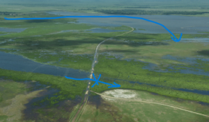
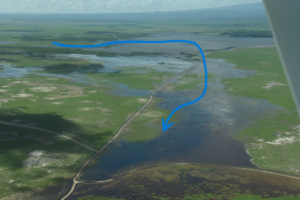
 

Flooding caused by the Sultan Hamud Road blocking the natura flow of Longinye Swamp into Lake Amboseli has nearly doubled the width of the swamp, drowned tourist circuits and inundated parts of Ol Tukai Lodge.


The Sultan Hamud Road seen running through the centre of the photo has blocked the natural flow of Longinye Swamp to the left. The dam has caused the flood waters to back up in Longinye and double its width. The backed-up flood water has cut a new route shown in blue. The new channel cuts across the Ol Tukai Road, through the flamingo lake and across the central portion of Amboseli where it drowns the airstrip and tourist circuits.
A view of the redirected flood waters in Longinye Swamp finding a new route across the Ol Tukai Road, into the flamingo lake and flooding the airstrip and tourist roads in the central portion of the national park.
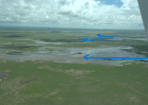
A view of the diverted flow of flood waters is shown by the blue arrow below. The diverted flow caused by the Sultan Hamud Road damming the natural flow of Longinye Swamp has caused extreme flooding in central Amboseli. The flood waters would otherwise flow along the natural channels marked by the upper blue arrows into Lake Amboseli.


The temporary measure taken to relieve the extreme 2020 flooding drained excess water in the central basin through the trough on the right into Simek and onto to Lake Amboseli, seen in the background. The temporary measure lessened the extent and duration of the 2026 flooding.


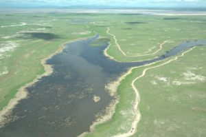
The natural channels draining flood waters into Lake Amboseli have been blocked by the Sultan Hamud and Namanga Roads. Here is a photo of one of the two main drainage channels feeding into Lake Amboseli. The natural channels would drain the flood waters into Lake Amboseli if the road blockages were fully opened.

Conclusions

The conclusions I draw from the March aerial survey are much the same as those I made in the earlier reports attached. The extreme flooding is due to the heavy erosion arising from the impact of permanent settlement on the higher grounds surrounding the national park. The flooding would drain into Lake Amboseli were it not for the Sultan Hamud and Namanga Road blocking the natural drainage channels.

The extreme flooding, damage to the roads and disruption to tourism caused by the 2026 could have been avoided had KWS allocated funds to do the road works needed for the flash flood to drain into the natural drainage channels feeding Lake Amboseli. It is neither expensive nor a difficult job to breach the road works causing the flooding.

The remedial action would direct the flood waters along their natural drainage channels to the northern edge of the park and into Lake Amboseli. The restoration would create new swamps and provide water and grazing to the Maasai at the edge of the park rather than them having to drive livestock into the central viewing areas. The expanded swamps would also create more dry-season grazing for wildlife, and expand tourist circuits across the national park.

The chronic and persistent lack of funding KWS has allocated Amboseli has prevented the management from carrying out the plans outlined in the Amboseli National Park Management Plan 2020-2030. The roads, infrastructure and tourist facilities are severely degraded as a result, largely due to the extreme flooding. A full assessment of the damage, the cost of restoration and remediation action should be commissioned before Kajiado County assumes the management of the park, lest it be blamed for its degraded state.

Previous reports on the flooding are given below.

Extreme flooding in Amboseli National Park. Action following Ol Tukai meeting of 17th February 2022

Livestock influx and an elevated flood alert

First, I want to confirm my concerns expressed at the meeting of 13th February about the large influx of livestock into the Amboseli early this year, heightening the risks of extreme floods in the event of very heavy long rains. A count ACP commissioned in mid-January shows the cattle influx was over 140,000 animals, more than double the resident population. The degradation caused will increase the flood runoff considerably at a time the swamps have also been expanded by extra underground inflow from Kilimanjaro.

Schedule of works for the short-term emergency plan

It was agreed at today’s meeting at Ol Tukai that KWS should proceed with the excavation works as soon as possible to ensure sufficient drainage capacity of flood waters before the long rains. More extensive works may be needed after the long rains when KWS is to BE allocate substantial funds for flood control in the new financial budget.

The short-term emergency plan estimated by KWS at 900,000/= will proceed as follows.

  1. The senior warden will determine by Tuesday the funds and in-kind equipment support it can commit to the short-term emergency plan.
  2. David Western will prepare satellite imagery of the Amboseli Basin detailing the swamps, drainage channels and roads as the base map for sketching the works to be done, including a) the expansion and deepening of the existing KWS trench from the Namanga Road to Lake Kioko, and b) sites on the Emali and Namanga Road where larger culverts are needed.
  3. Western will join the senior warden, KWS engineer and Ol Tukai Lodge representative on the ground no later than March 2nd to agree on the route the bulldozer will excavate, starting from Lake Kioko and working upslope along the existing KWS trench to the Namanga Road. The trenching must be completed before expanding the culverts on the Emali and Namanga Road to avoid flooding the trench and preventing bulldozer excavations. The larger culverts can be installed once the ditching is complete.
  4. KWS should be ready to start the bulldozer ditching the first week of March.


Report of 13 February 2020 with an additional note on risks of further extreme flooding in 2022

This report includes an additional note on the risks of further flooding if the drainage channels are not completed before the long rains of 2022.

Late 2021 and early 2022 have seen an enormous influx of cattle into the Amboseli area from Tanzania, Narok, the Rift, Namanga area and as far north as Simba due to drought conditions in these areas. The influx has furthered degraded the areas surrounding the park leaving it even more vulnerable to flooding than we experience in 2020 in the event of heavy long rains in the coming few months. This should add a note of urgency in moving ahead with flooding works before then to avoid the extreme damage to roads and visitation experienced in 2021.

 Background to the floods

The heavy rains in Kenya which began in September and continued through January caused extreme flooding in Amboseli National Park. By December the floods stretched from the Loitokitok to Namanga roads (see photos below) causing a closure of the airfield and viewing roads. Inbound air traffic was diverted to Tawi and Ol Doinyo Uas strips, resulting in transfer times to the lodges of up to three hours. The disruptions and tourist complaints carried in the social media led to cancellations and heavy revenue losses to the hotels and the Kenya Wildlife Service.

The extensive flooding in central Amboseli National Park caused the closure of the airfield to tourist traffic, a drop in visitation and a loss of revenues to the hoteliers and the Kenya Wildlife Service.

The lodges, led by Ol Tukai, called for a meeting in Amboseli on 18th January to see what could be done to open the airstrip, roads and solve the flooding problem. The meeting was chaired by the senior warden of Amboseli, Kenneth Nashu, and attended by KWS road engineers, Ol Tukai Serena and Ol Tukai lodge representatives, Amboseli Trust for Elephants and the Amboseli Conservation Program.

The warden noted that the flooding had grown worse in recent years, was causing extensive damage to the roads and threatened the future of tourism in the park. He asked the meeting to identify the source and cause of the flooding, restorative measures for the airfield and roads, and preventive measures to curb future floods. The lodge operators, raising their concerns about the disruptions to visitors and sharp drop in revenues, asked for emergency measures to restore the park.

Asked to give a background to the flooding, I made the following points and recommendations which I have supplemented with photos:

  • Until 1992 the basin didn’t flood as it now does. The extensive woodlands and shrub cover arrested and contained the heaviest rainfall in small isolated pans.
  • The loss of vegetation cover, coupled with extensive erosion from the higher elevations north and south of the basin, has caused the excessive inflow of water channeled into Longinye Swamp and out the far end across the central basin.
  • The erosion is due to the permanent settlement and heavy erosion around Amboseli. The extensive flooding began in 1992 after migratory livestock herders set up permanent homes. The heavy permanent grazing caused a loss of ground cover and heavy erosional runoff flooding into the basin. The erosion channels caused by the incoming floods rushing into Longinye Swamp during the rains can be seen in the photo below

    Flood channels caused by erosion off the higher ground surrounding the Amboseli National Park.
  • The clearest evidence of the flood waters originating off the heavily eroded lands around the park is captured in the satellite image below taken at the height of the floods. The flood waters are red-brown, the color of soils surrounding basin, rather than white soils of the basin and the flood pans filled by internal rainfall.

    Satellite photo of the Amboseli basin showing the red flood waters of Lake Amboseli and the flooding in central Amboseli. The red-brown color is due to erosional runoff from the higher ground surrounding Amboseli. Internal flood waters are white due to the lighter soils.
  • Two troughs stretching across the basin and visible from satellite imagery (below) drained Longinye Swamps into Lake Amboseli during historical periods of high rainfall. These channels have silted up over the decades.
    The central portion of Amboseli National Park showing the permanent swamps in dark green. The flood waters, shown in lighter green west of Ol Tukai, can be channeled into Lake Amboseli along the historical drainage lines stretching across the central plains into the lake.

    The central portion of Amboseli National Park showing the permanent swamps in dark green. The flood waters, shown in lighter green west of Ol Tukai, can be channeled into Lake Amboseli along the historical drainage lines stretching across the central plains into the lake.

  • The drainage troughs can be desilted to carry excess future flooding into Lake Amboseli. The survey and works should be completed before the next rains to avoid another tourist closure.
  • In the meantime, I landed at the airstrip before the meeting to show it is fully useable and accessible to four-wheel-drive traffic. The airstrip should be reopened immediately to avoid further tourist disruptions.
  • As a short-term measure can be taken to dump and level marram on the five kilometers or so of the main airstrip access and viewing roads. The roads, deflated by years of grading without recapping with marram to keep them raised above surface level, have become ribbon channels in many places.
  • In the longer term, a rangeland restoration program to combat erosion and restore pasture on the surrounding Ololorashi-Ogulului Group Ranch is underway. The program, funded by the Dutch NGO, Justdiggit through the Amboseli Ecosystem Trust and the African Conservation Centre, should reduce the erosional runoff into the basin in due course.
  • One proviso of flood abatement that may need to be considered is whether to retain the enough seasonal flood waters to maintain the great attraction the thousands of flamingoes and water birds have become to the park.
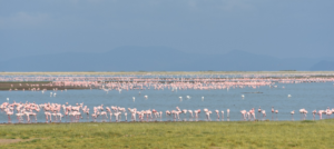
    The spectacle of thousands of flamingoes and water birds drawn by the Amboseli floods have become a grand attraction to park visitors.

    The way forward

  • The meeting agreed that KWS would move ahead immediately to open the airstrip and repair the access roads and main viewing circuits in the central park.
  • The lodge representative agreed to provide stop-gap funding if needed.
  • KWS, working in collaboration with the lodges and ACP, will conduct a topographic survey to determine the desilting levels needed to channel the Longinye Swamp excess flooding into Lake Amboseli.
  • The meeting was a positive step in engaging the tourism industry and conservation organizations in KWS’s planning and management of the park. The meeting should meet again within a month to review progress and become a permanent joint committee working for the future of Amboseli National Park and the larger ecosystem.

By Jonah Western

August 17, 2026

The deaths of two more elephants in the Amboseli area last week bring the total to 19, further fueling speculation

By Victor N. Mose

August 10, 2026

Amboseli Conservation Program (ACP) statisticians this week took Bayesian inference back 1 million years.

By Dr. David Jonah Western

August 5, 2026

Sixteen elephants have died in Amboseli in just a few weeks, alarming conservationists and the Maasai community

The extreme flooding in Amboseli. Preparing for El Niño

Authored by : David (Jonah) Western
Posted on September 25, 2026

A report to the governor of Kajiado and the Amboseli Transition Team

The extensive flooding in March of 2026 caused the closure of the Amboseli airstrip. The flooding was the most extensive since the 2020, though not as severe. The 2020 floods shut down air traffic for weeks, inundated Ol Tukai Lodge and drowned tourist circuits. The damage caused heavy losses to tour operators and hoteliers and costs to KWS in road repairs. In response to the disruptions, Ol Tukai Lodge called an emergency meeting of KWS, hoteliers and conservation organizations to assess the damage. The Amboseli Conservation Programme was I was asked report on the cause of the flooding and remedial action.

The report below concluded that the ultimate cause of the extreme flooding is the growth of farms and permanent pastoral settlements around the national park. Regular seasonal flooding, starting in 1992, has created a permanent flamingo lake in the centre of the park. The more immediate cause of flooding is the Namanga and Sultan Hamud roads blocking flash flooding along the natural drainage channels into Lake Amboseli.

The report concluded a permanent solution to the flooding lay widening the drainage channels across the two roads to allow the storm water to flow into Lake Amboseli. In the short term, the report recommended widening the drainage channels under the Namanga Road and deepening the natural trough leading into Simek Swamp to lessen the flooding.

The hoteliers, led by Ol Tukai, raised 900,000/= for KWS to undertake the short-term drainage works. KWS had no funds of its own to fuel the excavator to dig the trench. The excavations did alleviate extreme flooding until the prolonged heavy rains of 2026. Then, a week of heavy rains, followed by a 100 mm storm, overwhelmed the capacity of the ditching. Had KWS widened the two roads blocking the natural flow of water into Lake Amboseli, the extreme floods would have been prevented.

The technical Committee appointed to prepare a vision and strategy for Kajiado County to manage Amboseli raised concerns over the flooding in its 2024 report. The report urged the drainage channels on the Sultan Hamud and Namanga Roads be widened to avoid the extreme flooding. No action was taken by KWS for lack of funds allocated to undertake the task.

The two earlier reports on the Amboseli flooding are attached as background to the following report.


Report on extensive flooding in March 2026

H.E Governor Joseph Ole Lenku asked me to take stock of the March flooding and report back on preventative measures. I flew down to Amboseli on 24th of March to record the flooding from the air. The following photos give a visual presentation of the floods.

The Amboseli floods seen from Ol Tukai. The floods extended from the Kimana Road (foreground) to the airstrip seen at the far edge of the flooding. Lake Amboseli, the lowest point and drainage sump of Amboseli, is the red ribbon on the horizons.
The flooding seen from west of the airstrip looking towards Ol Tukai. Note the large flooded area between the airstrip and Ol Tukai. The area has become a permanent flamingo lake since 1992. The excess flood waters from the flamingo lake now drain into the central basin, drowning the airstrip and tourist circuits during heavy rains.


Observations

The flash flooding in March stretched across the central portion of Amboseli National Park from the airstrip to Ol Tukai. Lengthy sections of tourist circuits around Longinye Swamp and the airstrip were submerged. Most of the drowned roads lie well below the ground surface due to continuous grading without any replacement murram to build them up again. The airstrip was also submerged but was serviceable by the time I flew down on 24th March. The roads to the airstrip were, however, under water, making it impossible for tourist vehicles to reach the airstrip.

The March flooding was extensive but far less so than in 2020. The airstrip drained within ten days rather than the weeks under water in 2020 floods. The rapid drainage was due to large part to the temporary KWS ditching siphoning off much of the flood waters into Lake Kioko and on to Lake Amboseli.

The cause of flooding

The ultimate cause of the extreme flooding results from the heavy permanent settlement on the higher ground surrounding the Amboseli Basin and national park. The worst floods cascade down the lower slopes of Kilimanjaro south of Namalog and flow through Kalunyet into Longinye Swamp, as seen in the photo below.

Erosion and flooding caused by heavy settlement on the lower slopes of Kilimanjaro has created a seasonal stream flowing into Longinye Swamp through Kalunyet in the eastern section of Amboseli National Park.

The flood waters flowing into Longinye would naturally drain into the Lake Amboseli along a series of shallow troughs. The natural flow has been blocked by the elevated Sultan Hamud and Namanga Roads damming the natural flow. The damming has widened Longinye Swamp nearly twice its former width. The widening has drowned tourist circuits around Longinye and flooded parts of Ol Tukai Lodge, as seen below.
 

Flooding caused by the Sultan Hamud Road blocking the natura flow of Longinye Swamp into Lake Amboseli has nearly doubled the width of the swamp, drowned tourist circuits and inundated parts of Ol Tukai Lodge.


The Sultan Hamud Road seen running through the centre of the photo has blocked the natural flow of Longinye Swamp to the left. The dam has caused the flood waters to back up in Longinye and double its width. The backed-up flood water has cut a new route shown in blue. The new channel cuts across the Ol Tukai Road, through the flamingo lake and across the central portion of Amboseli where it drowns the airstrip and tourist circuits.
A view of the redirected flood waters in Longinye Swamp finding a new route across the Ol Tukai Road, into the flamingo lake and flooding the airstrip and tourist roads in the central portion of the national park.
A view of the diverted flow of flood waters is shown by the blue arrow below. The diverted flow caused by the Sultan Hamud Road damming the natural flow of Longinye Swamp has caused extreme flooding in central Amboseli. The flood waters would otherwise flow along the natural channels marked by the upper blue arrows into Lake Amboseli.


The temporary measure taken to relieve the extreme 2020 flooding drained excess water in the central basin through the trough on the right into Simek and onto to Lake Amboseli, seen in the background. The temporary measure lessened the extent and duration of the 2026 flooding.


The natural channels draining flood waters into Lake Amboseli have been blocked by the Sultan Hamud and Namanga Roads. Here is a photo of one of the two main drainage channels feeding into Lake Amboseli. The natural channels would drain the flood waters into Lake Amboseli if the road blockages were fully opened.

Conclusions

The conclusions I draw from the March aerial survey are much the same as those I made in the earlier reports attached. The extreme flooding is due to the heavy erosion arising from the impact of permanent settlement on the higher grounds surrounding the national park. The flooding would drain into Lake Amboseli were it not for the Sultan Hamud and Namanga Road blocking the natural drainage channels.

The extreme flooding, damage to the roads and disruption to tourism caused by the 2026 could have been avoided had KWS allocated funds to do the road works needed for the flash flood to drain into the natural drainage channels feeding Lake Amboseli. It is neither expensive nor a difficult job to breach the road works causing the flooding.

The remedial action would direct the flood waters along their natural drainage channels to the northern edge of the park and into Lake Amboseli. The restoration would create new swamps and provide water and grazing to the Maasai at the edge of the park rather than them having to drive livestock into the central viewing areas. The expanded swamps would also create more dry-season grazing for wildlife, and expand tourist circuits across the national park.

The chronic and persistent lack of funding KWS has allocated Amboseli has prevented the management from carrying out the plans outlined in the Amboseli National Park Management Plan 2020-2030. The roads, infrastructure and tourist facilities are severely degraded as a result, largely due to the extreme flooding. A full assessment of the damage, the cost of restoration and remediation action should be commissioned before Kajiado County assumes the management of the park, lest it be blamed for its degraded state.

Previous reports on the flooding are given below.

Extreme flooding in Amboseli National Park. Action following Ol Tukai meeting of 17th February 2022

Livestock influx and an elevated flood alert

First, I want to confirm my concerns expressed at the meeting of 13th February about the large influx of livestock into the Amboseli early this year, heightening the risks of extreme floods in the event of very heavy long rains. A count ACP commissioned in mid-January shows the cattle influx was over 140,000 animals, more than double the resident population. The degradation caused will increase the flood runoff considerably at a time the swamps have also been expanded by extra underground inflow from Kilimanjaro.

Schedule of works for the short-term emergency plan

It was agreed at today’s meeting at Ol Tukai that KWS should proceed with the excavation works as soon as possible to ensure sufficient drainage capacity of flood waters before the long rains. More extensive works may be needed after the long rains when KWS is to BE allocate substantial funds for flood control in the new financial budget.

The short-term emergency plan estimated by KWS at 900,000/= will proceed as follows.

  1. The senior warden will determine by Tuesday the funds and in-kind equipment support it can commit to the short-term emergency plan.
  2. David Western will prepare satellite imagery of the Amboseli Basin detailing the swamps, drainage channels and roads as the base map for sketching the works to be done, including a) the expansion and deepening of the existing KWS trench from the Namanga Road to Lake Kioko, and b) sites on the Emali and Namanga Road where larger culverts are needed.
  3. Western will join the senior warden, KWS engineer and Ol Tukai Lodge representative on the ground no later than March 2nd to agree on the route the bulldozer will excavate, starting from Lake Kioko and working upslope along the existing KWS trench to the Namanga Road. The trenching must be completed before expanding the culverts on the Emali and Namanga Road to avoid flooding the trench and preventing bulldozer excavations. The larger culverts can be installed once the ditching is complete.
  4. KWS should be ready to start the bulldozer ditching the first week of March.


Report of 13 February 2020 with an additional note on risks of further extreme flooding in 2022

This report includes an additional note on the risks of further flooding if the drainage channels are not completed before the long rains of 2022.

Late 2021 and early 2022 have seen an enormous influx of cattle into the Amboseli area from Tanzania, Narok, the Rift, Namanga area and as far north as Simba due to drought conditions in these areas. The influx has furthered degraded the areas surrounding the park leaving it even more vulnerable to flooding than we experience in 2020 in the event of heavy long rains in the coming few months. This should add a note of urgency in moving ahead with flooding works before then to avoid the extreme damage to roads and visitation experienced in 2021.

 Background to the floods

The heavy rains in Kenya which began in September and continued through January caused extreme flooding in Amboseli National Park. By December the floods stretched from the Loitokitok to Namanga roads (see photos below) causing a closure of the airfield and viewing roads. Inbound air traffic was diverted to Tawi and Ol Doinyo Uas strips, resulting in transfer times to the lodges of up to three hours. The disruptions and tourist complaints carried in the social media led to cancellations and heavy revenue losses to the hotels and the Kenya Wildlife Service.

The extensive flooding in central Amboseli National Park caused the closure of the airfield to tourist traffic, a drop in visitation and a loss of revenues to the hoteliers and the Kenya Wildlife Service.

The lodges, led by Ol Tukai, called for a meeting in Amboseli on 18th January to see what could be done to open the airstrip, roads and solve the flooding problem. The meeting was chaired by the senior warden of Amboseli, Kenneth Nashu, and attended by KWS road engineers, Ol Tukai Serena and Ol Tukai lodge representatives, Amboseli Trust for Elephants and the Amboseli Conservation Program.

The warden noted that the flooding had grown worse in recent years, was causing extensive damage to the roads and threatened the future of tourism in the park. He asked the meeting to identify the source and cause of the flooding, restorative measures for the airfield and roads, and preventive measures to curb future floods. The lodge operators, raising their concerns about the disruptions to visitors and sharp drop in revenues, asked for emergency measures to restore the park.

Asked to give a background to the flooding, I made the following points and recommendations which I have supplemented with photos:

  • Until 1992 the basin didn’t flood as it now does. The extensive woodlands and shrub cover arrested and contained the heaviest rainfall in small isolated pans.
  • The loss of vegetation cover, coupled with extensive erosion from the higher elevations north and south of the basin, has caused the excessive inflow of water channeled into Longinye Swamp and out the far end across the central basin.
  • The erosion is due to the permanent settlement and heavy erosion around Amboseli. The extensive flooding began in 1992 after migratory livestock herders set up permanent homes. The heavy permanent grazing caused a loss of ground cover and heavy erosional runoff flooding into the basin. The erosion channels caused by the incoming floods rushing into Longinye Swamp during the rains can be seen in the photo below

    Flood channels caused by erosion off the higher ground surrounding the Amboseli National Park.
  • The clearest evidence of the flood waters originating off the heavily eroded lands around the park is captured in the satellite image below taken at the height of the floods. The flood waters are red-brown, the color of soils surrounding basin, rather than white soils of the basin and the flood pans filled by internal rainfall.

    Satellite photo of the Amboseli basin showing the red flood waters of Lake Amboseli and the flooding in central Amboseli. The red-brown color is due to erosional runoff from the higher ground surrounding Amboseli. Internal flood waters are white due to the lighter soils.
  • Two troughs stretching across the basin and visible from satellite imagery (below) drained Longinye Swamps into Lake Amboseli during historical periods of high rainfall. These channels have silted up over the decades.
    The central portion of Amboseli National Park showing the permanent swamps in dark green. The flood waters, shown in lighter green west of Ol Tukai, can be channeled into Lake Amboseli along the historical drainage lines stretching across the central plains into the lake.

    The central portion of Amboseli National Park showing the permanent swamps in dark green. The flood waters, shown in lighter green west of Ol Tukai, can be channeled into Lake Amboseli along the historical drainage lines stretching across the central plains into the lake.

  • The drainage troughs can be desilted to carry excess future flooding into Lake Amboseli. The survey and works should be completed before the next rains to avoid another tourist closure.
  • In the meantime, I landed at the airstrip before the meeting to show it is fully useable and accessible to four-wheel-drive traffic. The airstrip should be reopened immediately to avoid further tourist disruptions.
  • As a short-term measure can be taken to dump and level marram on the five kilometers or so of the main airstrip access and viewing roads. The roads, deflated by years of grading without recapping with marram to keep them raised above surface level, have become ribbon channels in many places.
  • In the longer term, a rangeland restoration program to combat erosion and restore pasture on the surrounding Ololorashi-Ogulului Group Ranch is underway. The program, funded by the Dutch NGO, Justdiggit through the Amboseli Ecosystem Trust and the African Conservation Centre, should reduce the erosional runoff into the basin in due course.
  • One proviso of flood abatement that may need to be considered is whether to retain the enough seasonal flood waters to maintain the great attraction the thousands of flamingoes and water birds have become to the park.
    The spectacle of thousands of flamingoes and water birds drawn by the Amboseli floods have become a grand attraction to park visitors.

    The way forward

  • The meeting agreed that KWS would move ahead immediately to open the airstrip and repair the access roads and main viewing circuits in the central park.
  • The lodge representative agreed to provide stop-gap funding if needed.
  • KWS, working in collaboration with the lodges and ACP, will conduct a topographic survey to determine the desilting levels needed to channel the Longinye Swamp excess flooding into Lake Amboseli.
  • The meeting was a positive step in engaging the tourism industry and conservation organizations in KWS’s planning and management of the park. The meeting should meet again within a month to review progress and become a permanent joint committee working for the future of Amboseli National Park and the larger ecosystem.

By David (Jonah) Western

A report to the governor of Kajiado and the Amboseli Transition Team

The extensive flooding in March of 2026 caused the closure of the Amboseli airstrip. The flooding was the most extensive since the 2020, though not as severe. The 2020 floods shut down air traffic for weeks, inundated Ol Tukai Lodge and drowned tourist circuits. The damage caused heavy losses to tour operators and hoteliers and costs to KWS in road repairs. In response to the disruptions, Ol Tukai Lodge called an emergency meeting of KWS, hoteliers and conservation organizations to assess the damage. The Amboseli Conservation Programme was I was asked report on the cause of the flooding and remedial action.

The report below concluded that the ultimate cause of the extreme flooding is the growth of farms and permanent pastoral settlements around the national park. Regular seasonal flooding, starting in 1992, has created a permanent flamingo lake in the centre of the park. The more immediate cause of flooding is the Namanga and Sultan Hamud roads blocking flash flooding along the natural drainage channels into Lake Amboseli.

The report concluded a permanent solution to the flooding lay widening the drainage channels across the two roads to allow the storm water to flow into Lake Amboseli. In the short term, the report recommended widening the drainage channels under the Namanga Road and deepening the natural trough leading into Simek Swamp to lessen the flooding.

The hoteliers, led by Ol Tukai, raised 900,000/= for KWS to undertake the short-term drainage works. KWS had no funds of its own to fuel the excavator to dig the trench. The excavations did alleviate extreme flooding until the prolonged heavy rains of 2026. Then, a week of heavy rains, followed by a 100 mm storm, overwhelmed the capacity of the ditching. Had KWS widened the two roads blocking the natural flow of water into Lake Amboseli, the extreme floods would have been prevented.

The technical Committee appointed to prepare a vision and strategy for Kajiado County to manage Amboseli raised concerns over the flooding in its 2024 report. The report urged the drainage channels on the Sultan Hamud and Namanga Roads be widened to avoid the extreme flooding. No action was taken by KWS for lack of funds allocated to undertake the task.

The two earlier reports on the Amboseli flooding are attached as background to the following report.


Report on extensive flooding in March 2026

H.E Governor Joseph Ole Lenku asked me to take stock of the March flooding and report back on preventative measures. I flew down to Amboseli on 24th of March to record the flooding from the air. The following photos give a visual presentation of the floods.

The Amboseli floods seen from Ol Tukai. The floods extended from the Kimana Road (foreground) to the airstrip seen at the far edge of the flooding. Lake Amboseli, the lowest point and drainage sump of Amboseli, is the red ribbon on the horizons.
The flooding seen from west of the airstrip looking towards Ol Tukai. Note the large flooded area between the airstrip and Ol Tukai. The area has become a permanent flamingo lake since 1992. The excess flood waters from the flamingo lake now drain into the central basin, drowning the airstrip and tourist circuits during heavy rains.


Observations

The flash flooding in March stretched across the central portion of Amboseli National Park from the airstrip to Ol Tukai. Lengthy sections of tourist circuits around Longinye Swamp and the airstrip were submerged. Most of the drowned roads lie well below the ground surface due to continuous grading without any replacement murram to build them up again. The airstrip was also submerged but was serviceable by the time I flew down on 24th March. The roads to the airstrip were, however, under water, making it impossible for tourist vehicles to reach the airstrip.

The March flooding was extensive but far less so than in 2020. The airstrip drained within ten days rather than the weeks under water in 2020 floods. The rapid drainage was due to large part to the temporary KWS ditching siphoning off much of the flood waters into Lake Kioko and on to Lake Amboseli.

The cause of flooding

The ultimate cause of the extreme flooding results from the heavy permanent settlement on the higher ground surrounding the Amboseli Basin and national park. The worst floods cascade down the lower slopes of Kilimanjaro south of Namalog and flow through Kalunyet into Longinye Swamp, as seen in the photo below.

Erosion and flooding caused by heavy settlement on the lower slopes of Kilimanjaro has created a seasonal stream flowing into Longinye Swamp through Kalunyet in the eastern section of Amboseli National Park.

The flood waters flowing into Longinye would naturally drain into the Lake Amboseli along a series of shallow troughs. The natural flow has been blocked by the elevated Sultan Hamud and Namanga Roads damming the natural flow. The damming has widened Longinye Swamp nearly twice its former width. The widening has drowned tourist circuits around Longinye and flooded parts of Ol Tukai Lodge, as seen below.
 

Flooding caused by the Sultan Hamud Road blocking the natura flow of Longinye Swamp into Lake Amboseli has nearly doubled the width of the swamp, drowned tourist circuits and inundated parts of Ol Tukai Lodge.


The Sultan Hamud Road seen running through the centre of the photo has blocked the natural flow of Longinye Swamp to the left. The dam has caused the flood waters to back up in Longinye and double its width. The backed-up flood water has cut a new route shown in blue. The new channel cuts across the Ol Tukai Road, through the flamingo lake and across the central portion of Amboseli where it drowns the airstrip and tourist circuits.
A view of the redirected flood waters in Longinye Swamp finding a new route across the Ol Tukai Road, into the flamingo lake and flooding the airstrip and tourist roads in the central portion of the national park.
A view of the diverted flow of flood waters is shown by the blue arrow below. The diverted flow caused by the Sultan Hamud Road damming the natural flow of Longinye Swamp has caused extreme flooding in central Amboseli. The flood waters would otherwise flow along the natural channels marked by the upper blue arrows into Lake Amboseli.


The temporary measure taken to relieve the extreme 2020 flooding drained excess water in the central basin through the trough on the right into Simek and onto to Lake Amboseli, seen in the background. The temporary measure lessened the extent and duration of the 2026 flooding.


The natural channels draining flood waters into Lake Amboseli have been blocked by the Sultan Hamud and Namanga Roads. Here is a photo of one of the two main drainage channels feeding into Lake Amboseli. The natural channels would drain the flood waters into Lake Amboseli if the road blockages were fully opened.

Conclusions

The conclusions I draw from the March aerial survey are much the same as those I made in the earlier reports attached. The extreme flooding is due to the heavy erosion arising from the impact of permanent settlement on the higher grounds surrounding the national park. The flooding would drain into Lake Amboseli were it not for the Sultan Hamud and Namanga Road blocking the natural drainage channels.

The extreme flooding, damage to the roads and disruption to tourism caused by the 2026 could have been avoided had KWS allocated funds to do the road works needed for the flash flood to drain into the natural drainage channels feeding Lake Amboseli. It is neither expensive nor a difficult job to breach the road works causing the flooding.

The remedial action would direct the flood waters along their natural drainage channels to the northern edge of the park and into Lake Amboseli. The restoration would create new swamps and provide water and grazing to the Maasai at the edge of the park rather than them having to drive livestock into the central viewing areas. The expanded swamps would also create more dry-season grazing for wildlife, and expand tourist circuits across the national park.

The chronic and persistent lack of funding KWS has allocated Amboseli has prevented the management from carrying out the plans outlined in the Amboseli National Park Management Plan 2020-2030. The roads, infrastructure and tourist facilities are severely degraded as a result, largely due to the extreme flooding. A full assessment of the damage, the cost of restoration and remediation action should be commissioned before Kajiado County assumes the management of the park, lest it be blamed for its degraded state.

Previous reports on the flooding are given below.

Extreme flooding in Amboseli National Park. Action following Ol Tukai meeting of 17th February 2022

Livestock influx and an elevated flood alert

First, I want to confirm my concerns expressed at the meeting of 13th February about the large influx of livestock into the Amboseli early this year, heightening the risks of extreme floods in the event of very heavy long rains. A count ACP commissioned in mid-January shows the cattle influx was over 140,000 animals, more than double the resident population. The degradation caused will increase the flood runoff considerably at a time the swamps have also been expanded by extra underground inflow from Kilimanjaro.

Schedule of works for the short-term emergency plan

It was agreed at today’s meeting at Ol Tukai that KWS should proceed with the excavation works as soon as possible to ensure sufficient drainage capacity of flood waters before the long rains. More extensive works may be needed after the long rains when KWS is to BE allocate substantial funds for flood control in the new financial budget.

The short-term emergency plan estimated by KWS at 900,000/= will proceed as follows.

  1. The senior warden will determine by Tuesday the funds and in-kind equipment support it can commit to the short-term emergency plan.
  2. David Western will prepare satellite imagery of the Amboseli Basin detailing the swamps, drainage channels and roads as the base map for sketching the works to be done, including a) the expansion and deepening of the existing KWS trench from the Namanga Road to Lake Kioko, and b) sites on the Emali and Namanga Road where larger culverts are needed.
  3. Western will join the senior warden, KWS engineer and Ol Tukai Lodge representative on the ground no later than March 2nd to agree on the route the bulldozer will excavate, starting from Lake Kioko and working upslope along the existing KWS trench to the Namanga Road. The trenching must be completed before expanding the culverts on the Emali and Namanga Road to avoid flooding the trench and preventing bulldozer excavations. The larger culverts can be installed once the ditching is complete.
  4. KWS should be ready to start the bulldozer ditching the first week of March.


Report of 13 February 2020 with an additional note on risks of further extreme flooding in 2022

This report includes an additional note on the risks of further flooding if the drainage channels are not completed before the long rains of 2022.

Late 2021 and early 2022 have seen an enormous influx of cattle into the Amboseli area from Tanzania, Narok, the Rift, Namanga area and as far north as Simba due to drought conditions in these areas. The influx has furthered degraded the areas surrounding the park leaving it even more vulnerable to flooding than we experience in 2020 in the event of heavy long rains in the coming few months. This should add a note of urgency in moving ahead with flooding works before then to avoid the extreme damage to roads and visitation experienced in 2021.

 Background to the floods

The heavy rains in Kenya which began in September and continued through January caused extreme flooding in Amboseli National Park. By December the floods stretched from the Loitokitok to Namanga roads (see photos below) causing a closure of the airfield and viewing roads. Inbound air traffic was diverted to Tawi and Ol Doinyo Uas strips, resulting in transfer times to the lodges of up to three hours. The disruptions and tourist complaints carried in the social media led to cancellations and heavy revenue losses to the hotels and the Kenya Wildlife Service.

The extensive flooding in central Amboseli National Park caused the closure of the airfield to tourist traffic, a drop in visitation and a loss of revenues to the hoteliers and the Kenya Wildlife Service.

The lodges, led by Ol Tukai, called for a meeting in Amboseli on 18th January to see what could be done to open the airstrip, roads and solve the flooding problem. The meeting was chaired by the senior warden of Amboseli, Kenneth Nashu, and attended by KWS road engineers, Ol Tukai Serena and Ol Tukai lodge representatives, Amboseli Trust for Elephants and the Amboseli Conservation Program.

The warden noted that the flooding had grown worse in recent years, was causing extensive damage to the roads and threatened the future of tourism in the park. He asked the meeting to identify the source and cause of the flooding, restorative measures for the airfield and roads, and preventive measures to curb future floods. The lodge operators, raising their concerns about the disruptions to visitors and sharp drop in revenues, asked for emergency measures to restore the park.

Asked to give a background to the flooding, I made the following points and recommendations which I have supplemented with photos:

  • Until 1992 the basin didn’t flood as it now does. The extensive woodlands and shrub cover arrested and contained the heaviest rainfall in small isolated pans.
  • The loss of vegetation cover, coupled with extensive erosion from the higher elevations north and south of the basin, has caused the excessive inflow of water channeled into Longinye Swamp and out the far end across the central basin.
  • The erosion is due to the permanent settlement and heavy erosion around Amboseli. The extensive flooding began in 1992 after migratory livestock herders set up permanent homes. The heavy permanent grazing caused a loss of ground cover and heavy erosional runoff flooding into the basin. The erosion channels caused by the incoming floods rushing into Longinye Swamp during the rains can be seen in the photo below

    Flood channels caused by erosion off the higher ground surrounding the Amboseli National Park.
  • The clearest evidence of the flood waters originating off the heavily eroded lands around the park is captured in the satellite image below taken at the height of the floods. The flood waters are red-brown, the color of soils surrounding basin, rather than white soils of the basin and the flood pans filled by internal rainfall.

    Satellite photo of the Amboseli basin showing the red flood waters of Lake Amboseli and the flooding in central Amboseli. The red-brown color is due to erosional runoff from the higher ground surrounding Amboseli. Internal flood waters are white due to the lighter soils.
  • Two troughs stretching across the basin and visible from satellite imagery (below) drained Longinye Swamps into Lake Amboseli during historical periods of high rainfall. These channels have silted up over the decades.
    The central portion of Amboseli National Park showing the permanent swamps in dark green. The flood waters, shown in lighter green west of Ol Tukai, can be channeled into Lake Amboseli along the historical drainage lines stretching across the central plains into the lake.

    The central portion of Amboseli National Park showing the permanent swamps in dark green. The flood waters, shown in lighter green west of Ol Tukai, can be channeled into Lake Amboseli along the historical drainage lines stretching across the central plains into the lake.

  • The drainage troughs can be desilted to carry excess future flooding into Lake Amboseli. The survey and works should be completed before the next rains to avoid another tourist closure.
  • In the meantime, I landed at the airstrip before the meeting to show it is fully useable and accessible to four-wheel-drive traffic. The airstrip should be reopened immediately to avoid further tourist disruptions.
  • As a short-term measure can be taken to dump and level marram on the five kilometers or so of the main airstrip access and viewing roads. The roads, deflated by years of grading without recapping with marram to keep them raised above surface level, have become ribbon channels in many places.
  • In the longer term, a rangeland restoration program to combat erosion and restore pasture on the surrounding Ololorashi-Ogulului Group Ranch is underway. The program, funded by the Dutch NGO, Justdiggit through the Amboseli Ecosystem Trust and the African Conservation Centre, should reduce the erosional runoff into the basin in due course.
  • One proviso of flood abatement that may need to be considered is whether to retain the enough seasonal flood waters to maintain the great attraction the thousands of flamingoes and water birds have become to the park.
    The spectacle of thousands of flamingoes and water birds drawn by the Amboseli floods have become a grand attraction to park visitors.

    The way forward

  • The meeting agreed that KWS would move ahead immediately to open the airstrip and repair the access roads and main viewing circuits in the central park.
  • The lodge representative agreed to provide stop-gap funding if needed.
  • KWS, working in collaboration with the lodges and ACP, will conduct a topographic survey to determine the desilting levels needed to channel the Longinye Swamp excess flooding into Lake Amboseli.
  • The meeting was a positive step in engaging the tourism industry and conservation organizations in KWS’s planning and management of the park. The meeting should meet again within a month to review progress and become a permanent joint committee working for the future of Amboseli National Park and the larger ecosystem.

By Jonah Western

August 17, 2026

The deaths of two more elephants in the Amboseli area last week bring the total to 19, further fueling speculation

By Victor N. Mose

August 10, 2026

Amboseli Conservation Program (ACP) statisticians this week took Bayesian inference back 1 million years.

By Dr. David Jonah Western

August 5, 2026

Sixteen elephants have died in Amboseli in just a few weeks, alarming conservationists and the Maasai community

Posted on September 25, 2026

By David (Jonah) Western

A report to the governor of Kajiado and the Amboseli Transition Team

The extensive flooding in March of 2026 caused the closure of the Amboseli airstrip. The flooding was the most extensive since the 2020, though not as severe. The 2020 floods shut down air traffic for weeks, inundated Ol Tukai Lodge and drowned tourist circuits. The damage caused heavy losses to tour operators and hoteliers and costs to KWS in road repairs. In response to the disruptions, Ol Tukai Lodge called an emergency meeting of KWS, hoteliers and conservation organizations to assess the damage. The Amboseli Conservation Programme was I was asked report on the cause of the flooding and remedial action.

The report below concluded that the ultimate cause of the extreme flooding is the growth of farms and permanent pastoral settlements around the national park. Regular seasonal flooding, starting in 1992, has created a permanent flamingo lake in the centre of the park. The more immediate cause of flooding is the Namanga and Sultan Hamud roads blocking flash flooding along the natural drainage channels into Lake Amboseli.

The report concluded a permanent solution to the flooding lay widening the drainage channels across the two roads to allow the storm water to flow into Lake Amboseli. In the short term, the report recommended widening the drainage channels under the Namanga Road and deepening the natural trough leading into Simek Swamp to lessen the flooding.

The hoteliers, led by Ol Tukai, raised 900,000/= for KWS to undertake the short-term drainage works. KWS had no funds of its own to fuel the excavator to dig the trench. The excavations did alleviate extreme flooding until the prolonged heavy rains of 2026. Then, a week of heavy rains, followed by a 100 mm storm, overwhelmed the capacity of the ditching. Had KWS widened the two roads blocking the natural flow of water into Lake Amboseli, the extreme floods would have been prevented.

The technical Committee appointed to prepare a vision and strategy for Kajiado County to manage Amboseli raised concerns over the flooding in its 2024 report. The report urged the drainage channels on the Sultan Hamud and Namanga Roads be widened to avoid the extreme flooding. No action was taken by KWS for lack of funds allocated to undertake the task.

The two earlier reports on the Amboseli flooding are attached as background to the following report.


Report on extensive flooding in March 2026

H.E Governor Joseph Ole Lenku asked me to take stock of the March flooding and report back on preventative measures. I flew down to Amboseli on 24th of March to record the flooding from the air. The following photos give a visual presentation of the floods.

The Amboseli floods seen from Ol Tukai. The floods extended from the Kimana Road (foreground) to the airstrip seen at the far edge of the flooding. Lake Amboseli, the lowest point and drainage sump of Amboseli, is the red ribbon on the horizons.
The flooding seen from west of the airstrip looking towards Ol Tukai. Note the large flooded area between the airstrip and Ol Tukai. The area has become a permanent flamingo lake since 1992. The excess flood waters from the flamingo lake now drain into the central basin, drowning the airstrip and tourist circuits during heavy rains.


Observations

The flash flooding in March stretched across the central portion of Amboseli National Park from the airstrip to Ol Tukai. Lengthy sections of tourist circuits around Longinye Swamp and the airstrip were submerged. Most of the drowned roads lie well below the ground surface due to continuous grading without any replacement murram to build them up again. The airstrip was also submerged but was serviceable by the time I flew down on 24th March. The roads to the airstrip were, however, under water, making it impossible for tourist vehicles to reach the airstrip.

The March flooding was extensive but far less so than in 2020. The airstrip drained within ten days rather than the weeks under water in 2020 floods. The rapid drainage was due to large part to the temporary KWS ditching siphoning off much of the flood waters into Lake Kioko and on to Lake Amboseli.

The cause of flooding

The ultimate cause of the extreme flooding results from the heavy permanent settlement on the higher ground surrounding the Amboseli Basin and national park. The worst floods cascade down the lower slopes of Kilimanjaro south of Namalog and flow through Kalunyet into Longinye Swamp, as seen in the photo below.

Erosion and flooding caused by heavy settlement on the lower slopes of Kilimanjaro has created a seasonal stream flowing into Longinye Swamp through Kalunyet in the eastern section of Amboseli National Park.

The flood waters flowing into Longinye would naturally drain into the Lake Amboseli along a series of shallow troughs. The natural flow has been blocked by the elevated Sultan Hamud and Namanga Roads damming the natural flow. The damming has widened Longinye Swamp nearly twice its former width. The widening has drowned tourist circuits around Longinye and flooded parts of Ol Tukai Lodge, as seen below.
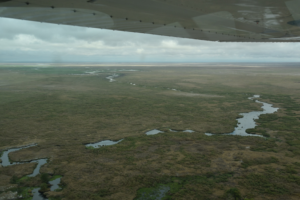
 

Flooding caused by the Sultan Hamud Road blocking the natura flow of Longinye Swamp into Lake Amboseli has nearly doubled the width of the swamp, drowned tourist circuits and inundated parts of Ol Tukai Lodge.


The Sultan Hamud Road seen running through the centre of the photo has blocked the natural flow of Longinye Swamp to the left. The dam has caused the flood waters to back up in Longinye and double its width. The backed-up flood water has cut a new route shown in blue. The new channel cuts across the Ol Tukai Road, through the flamingo lake and across the central portion of Amboseli where it drowns the airstrip and tourist circuits.
A view of the redirected flood waters in Longinye Swamp finding a new route across the Ol Tukai Road, into the flamingo lake and flooding the airstrip and tourist roads in the central portion of the national park.
A view of the diverted flow of flood waters is shown by the blue arrow below. The diverted flow caused by the Sultan Hamud Road damming the natural flow of Longinye Swamp has caused extreme flooding in central Amboseli. The flood waters would otherwise flow along the natural channels marked by the upper blue arrows into Lake Amboseli.


The temporary measure taken to relieve the extreme 2020 flooding drained excess water in the central basin through the trough on the right into Simek and onto to Lake Amboseli, seen in the background. The temporary measure lessened the extent and duration of the 2026 flooding.


The natural channels draining flood waters into Lake Amboseli have been blocked by the Sultan Hamud and Namanga Roads. Here is a photo of one of the two main drainage channels feeding into Lake Amboseli. The natural channels would drain the flood waters into Lake Amboseli if the road blockages were fully opened.

Conclusions

The conclusions I draw from the March aerial survey are much the same as those I made in the earlier reports attached. The extreme flooding is due to the heavy erosion arising from the impact of permanent settlement on the higher grounds surrounding the national park. The flooding would drain into Lake Amboseli were it not for the Sultan Hamud and Namanga Road blocking the natural drainage channels.

The extreme flooding, damage to the roads and disruption to tourism caused by the 2026 could have been avoided had KWS allocated funds to do the road works needed for the flash flood to drain into the natural drainage channels feeding Lake Amboseli. It is neither expensive nor a difficult job to breach the road works causing the flooding.

The remedial action would direct the flood waters along their natural drainage channels to the northern edge of the park and into Lake Amboseli. The restoration would create new swamps and provide water and grazing to the Maasai at the edge of the park rather than them having to drive livestock into the central viewing areas. The expanded swamps would also create more dry-season grazing for wildlife, and expand tourist circuits across the national park.

The chronic and persistent lack of funding KWS has allocated Amboseli has prevented the management from carrying out the plans outlined in the Amboseli National Park Management Plan 2020-2030. The roads, infrastructure and tourist facilities are severely degraded as a result, largely due to the extreme flooding. A full assessment of the damage, the cost of restoration and remediation action should be commissioned before Kajiado County assumes the management of the park, lest it be blamed for its degraded state.

Previous reports on the flooding are given below.

Extreme flooding in Amboseli National Park. Action following Ol Tukai meeting of 17th February 2022

Livestock influx and an elevated flood alert

First, I want to confirm my concerns expressed at the meeting of 13th February about the large influx of livestock into the Amboseli early this year, heightening the risks of extreme floods in the event of very heavy long rains. A count ACP commissioned in mid-January shows the cattle influx was over 140,000 animals, more than double the resident population. The degradation caused will increase the flood runoff considerably at a time the swamps have also been expanded by extra underground inflow from Kilimanjaro.

Schedule of works for the short-term emergency plan

It was agreed at today’s meeting at Ol Tukai that KWS should proceed with the excavation works as soon as possible to ensure sufficient drainage capacity of flood waters before the long rains. More extensive works may be needed after the long rains when KWS is to BE allocate substantial funds for flood control in the new financial budget.

The short-term emergency plan estimated by KWS at 900,000/= will proceed as follows.

  1. The senior warden will determine by Tuesday the funds and in-kind equipment support it can commit to the short-term emergency plan.
  2. David Western will prepare satellite imagery of the Amboseli Basin detailing the swamps, drainage channels and roads as the base map for sketching the works to be done, including a) the expansion and deepening of the existing KWS trench from the Namanga Road to Lake Kioko, and b) sites on the Emali and Namanga Road where larger culverts are needed.
  3. Western will join the senior warden, KWS engineer and Ol Tukai Lodge representative on the ground no later than March 2nd to agree on the route the bulldozer will excavate, starting from Lake Kioko and working upslope along the existing KWS trench to the Namanga Road. The trenching must be completed before expanding the culverts on the Emali and Namanga Road to avoid flooding the trench and preventing bulldozer excavations. The larger culverts can be installed once the ditching is complete.
  4. KWS should be ready to start the bulldozer ditching the first week of March.


Report of 13 February 2020 with an additional note on risks of further extreme flooding in 2022

This report includes an additional note on the risks of further flooding if the drainage channels are not completed before the long rains of 2022.

Late 2021 and early 2022 have seen an enormous influx of cattle into the Amboseli area from Tanzania, Narok, the Rift, Namanga area and as far north as Simba due to drought conditions in these areas. The influx has furthered degraded the areas surrounding the park leaving it even more vulnerable to flooding than we experience in 2020 in the event of heavy long rains in the coming few months. This should add a note of urgency in moving ahead with flooding works before then to avoid the extreme damage to roads and visitation experienced in 2021.

 Background to the floods

The heavy rains in Kenya which began in September and continued through January caused extreme flooding in Amboseli National Park. By December the floods stretched from the Loitokitok to Namanga roads (see photos below) causing a closure of the airfield and viewing roads. Inbound air traffic was diverted to Tawi and Ol Doinyo Uas strips, resulting in transfer times to the lodges of up to three hours. The disruptions and tourist complaints carried in the social media led to cancellations and heavy revenue losses to the hotels and the Kenya Wildlife Service.
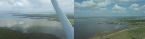
The extensive flooding in central Amboseli National Park caused the closure of the airfield to tourist traffic, a drop in visitation and a loss of revenues to the hoteliers and the Kenya Wildlife Service.

The lodges, led by Ol Tukai, called for a meeting in Amboseli on 18th January to see what could be done to open the airstrip, roads and solve the flooding problem. The meeting was chaired by the senior warden of Amboseli, Kenneth Nashu, and attended by KWS road engineers, Ol Tukai Serena and Ol Tukai lodge representatives, Amboseli Trust for Elephants and the Amboseli Conservation Program.

The warden noted that the flooding had grown worse in recent years, was causing extensive damage to the roads and threatened the future of tourism in the park. He asked the meeting to identify the source and cause of the flooding, restorative measures for the airfield and roads, and preventive measures to curb future floods. The lodge operators, raising their concerns about the disruptions to visitors and sharp drop in revenues, asked for emergency measures to restore the park.

Asked to give a background to the flooding, I made the following points and recommendations which I have supplemented with photos:
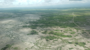
  • Until 1992 the basin didn’t flood as it now does. The extensive woodlands and shrub cover arrested and contained the heaviest rainfall in small isolated pans.
  • The loss of vegetation cover, coupled with extensive erosion from the higher elevations north and south of the basin, has caused the excessive inflow of water channeled into Longinye Swamp and out the far end across the central basin.
  • The erosion is due to the permanent settlement and heavy erosion around Amboseli. The extensive flooding began in 1992 after migratory livestock herders set up permanent homes. The heavy permanent grazing caused a loss of ground cover and heavy erosional runoff flooding into the basin. The erosion channels caused by the incoming floods rushing into Longinye Swamp during the rains can be seen in the photo below

    Flood channels caused by erosion off the higher ground surrounding the Amboseli National Park.
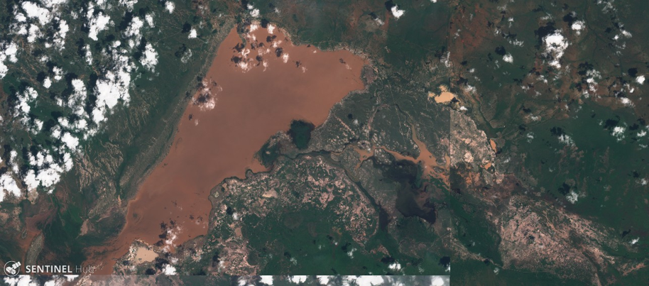
  • The clearest evidence of the flood waters originating off the heavily eroded lands around the park is captured in the satellite image below taken at the height of the floods. The flood waters are red-brown, the color of soils surrounding basin, rather than white soils of the basin and the flood pans filled by internal rainfall.

    Satellite photo of the Amboseli basin showing the red flood waters of Lake Amboseli and the flooding in central Amboseli. The red-brown color is due to erosional runoff from the higher ground surrounding Amboseli. Internal flood waters are white due to the lighter soils.
  • Two troughs stretching across the basin and visible from satellite imagery (below) drained Longinye Swamps into Lake Amboseli during historical periods of high rainfall. These channels have silted up over the decades.
    The central portion of Amboseli National Park showing the permanent swamps in dark green. The flood waters, shown in lighter green west of Ol Tukai, can be channeled into Lake Amboseli along the historical drainage lines stretching across the central plains into the lake.
    The central portion of Amboseli National Park showing the permanent swamps in dark green. The flood waters, shown in lighter green west of Ol Tukai, can be channeled into Lake Amboseli along the historical drainage lines stretching across the central plains into the lake.

  • The drainage troughs can be desilted to carry excess future flooding into Lake Amboseli. The survey and works should be completed before the next rains to avoid another tourist closure.
  • In the meantime, I landed at the airstrip before the meeting to show it is fully useable and accessible to four-wheel-drive traffic. The airstrip should be reopened immediately to avoid further tourist disruptions.
  • As a short-term measure can be taken to dump and level marram on the five kilometers or so of the main airstrip access and viewing roads. The roads, deflated by years of grading without recapping with marram to keep them raised above surface level, have become ribbon channels in many places.
  • In the longer term, a rangeland restoration program to combat erosion and restore pasture on the surrounding Ololorashi-Ogulului Group Ranch is underway. The program, funded by the Dutch NGO, Justdiggit through the Amboseli Ecosystem Trust and the African Conservation Centre, should reduce the erosional runoff into the basin in due course.
  • One proviso of flood abatement that may need to be considered is whether to retain the enough seasonal flood waters to maintain the great attraction the thousands of flamingoes and water birds have become to the park.
    The spectacle of thousands of flamingoes and water birds drawn by the Amboseli floods have become a grand attraction to park visitors.

    The way forward

  • The meeting agreed that KWS would move ahead immediately to open the airstrip and repair the access roads and main viewing circuits in the central park.
  • The lodge representative agreed to provide stop-gap funding if needed.
  • KWS, working in collaboration with the lodges and ACP, will conduct a topographic survey to determine the desilting levels needed to channel the Longinye Swamp excess flooding into Lake Amboseli.
  • The meeting was a positive step in engaging the tourism industry and conservation organizations in KWS’s planning and management of the park. The meeting should meet again within a month to review progress and become a permanent joint committee working for the future of Amboseli National Park and the larger ecosystem.

Recent Posts

By David (Jonah) Western

September 25, 2026

The extensive flooding in March of 2026 caused the closure of the Amboseli airstrip.

By Jonah Western

August 17, 2026

The deaths of two more elephants in the Amboseli area last week bring the total to 19, further fueling speculation

By Victor N. Mose

August 10, 2026

Amboseli Conservation Program (ACP) statisticians this week took Bayesian inference back 1 million years.

By Dr. David Jonah Western

August 5, 2026

Sixteen elephants have died in Amboseli in just a few weeks, alarming conservationists and the Maasai community

By David Western, Victor N. Mose*, David Maitumo, Winfridah Kemunto, Sakimba Kimiti, Immaculate Ombongi, Samuel Lekanaiya, Paul Kasaine and Sunte Kimiti

July 31, 2026

The latest Amboseli Ecosystem Outlook Report combines perspectives from local herders and livestock traders

By Victor N. Mose

July 22, 2026

Fireworks displaying EU–Kenya relations rocked the skyline in Loresho at Shamba Café, lighting up the evening sky

By Victor N. Mose

May 22, 2026

Herders in Amboseli gathered under the shade of an acacia tree for a parliamentary style debate on co-production.

By David Western, Victor N. Mose* , David Maitumo, Winfridah Kemunto, Sakimba Kimiti, Immaculate Ombongi, Samuel Lekanaiya, Paul Kasaine and Sunte Kimiti

May 20, 2026

As a result of the unseasonal rains in January to April, conditions in Amboseli have changed from a severe drought

By Victor N. Mose

May 12, 2026

Staff at the Embassy of Kenya in Vienna were treated to an “elephant show” following Angela Mumbi’s presentation

By Victor N. Mose

April 4, 2026

The MOSAIC meeting in Montpellier focused on practical solutions for shared environmental and health challenges

Contact Us

Amboseli Conservation Program
P.O Box 15289-00509 or 62844-00200
Nairobi, Kenya.

Tel/Fax: +254 20 891360 / 891751
Email: acc@acc.or.ke