
Abstract
Our study traces the transition from traditional livestock practices based on seasonal migrations to permanent settlements over the last half century. The number of settlements has grown seven-fold with the rising human population. The changing location, size, style and clustering of settlements and permanent houses reflects the changing lives and lifestyles of pastoralists in Amboseli choosing smaller family units close to social amenities.
ACP has documented the ecological degradation caused by subdivision in the Kaputei Section and permanent settlement in the Amboseli ecosystem. The heavy permanent grazing has caused of loss of pastures, erosion and extreme flooding in Amboseli National Park.
A review of the Olgulului-Ololorashi subdivision plans by National Environment Management Authority raised concerns over land loss and degradation caused by subdivision and sedentarization. Although the plans align with the Amboseli Ecosystem Management Plan 2020-2024, they should be incorporated into the Kajiado County Spatial Plan to ensure enforcement and compliance with the Presidential Decree and Governor of Kajiado’s directive halt to land sales pending land conservation plans.
Introduction
Amboseli Conservation Program (ACP) began monitoring the number and location of Maasai settlements in the 1960s as a way to track the seasonal migrations, livestock distributions and pastoral households using the Amboseli area (Western, 1973, 1975, 1976) . Monitored over the decades since then, the settlement study shows how families have changed their use of households in shifting from seasonal migrations to sedentary lives.
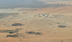
Traditional Maasai settlements (enkang, plural enkangiti) are thorn corrals enclosing an outer ring of dung-covered huts (ngaji plural ngajiki), a cattle compound, and inner rings of sheep and goat compounds. The diameter of a settlement approximates the number of livestock enclosed, the number of gates the number of families sharing the enkang, and the number of huts the total population in the compound based on four to five individuals in each hut. Settlements are located strategically by herders to give their livestock ready access to water and grazing grounds. The location and occupation of settlements also track the seasonal migrations between wet and dry ranges, and the progression across pastures in the dry season. ACP studies looked into the site selection of settlements and the impact of settlements on vegetation (Western & Dunne, 1979). Andrew Muchiru et al., 2008 and Muchiru et al., 2009 went on to look at the imprint of abandoned settlements on soil nutrients and plant and herbivore succession on abandoned sites up to a century later.
The settlement mapping program was extended across 8,700 km2 of eastern Kajiado in 1974 using aerial sample counts (Western, 1976a). The counts included thatch and tin-roofed huts to track growth of permanent settlements in response to the spread of farms and land subdivision. The results can be found in (Western et al., 2021). We backdated settlement number and distribution to 1950 using highresolution aerial photography conducted across southern Kenya by the British Royal Airforce.
We began total aerial count of the settlements in the Amboseli Basin dry season range in 1975 and continued the counts until December 2019 when we switched to Google satellite imagery after calibrating against ground and aerial counts.
Download full the bulletin below.
From seasonal migrations to permanent settlements among pastoralist in Amboseli: 1950-2024
Abstract
Our study traces the transition from traditional livestock practices based on seasonal migrations to permanent settlements over the last half century. The number of settlements has grown seven-fold with the rising human population. The changing location, size, style and clustering of settlements and permanent houses reflects the changing lives and lifestyles of pastoralists in Amboseli choosing smaller family units close to social amenities.
ACP has documented the ecological degradation caused by subdivision in the Kaputei Section and permanent settlement in the Amboseli ecosystem. The heavy permanent grazing has caused of loss of pastures, erosion and extreme flooding in Amboseli National Park.
A review of the Olgulului-Ololorashi subdivision plans by National Environment Management Authority raised concerns over land loss and degradation caused by subdivision and sedentarization. Although the plans align with the Amboseli Ecosystem Management Plan 2020-2024, they should be incorporated into the Kajiado County Spatial Plan to ensure enforcement and compliance with the Presidential Decree and Governor of Kajiado’s directive halt to land sales pending land conservation plans.
Introduction
Amboseli Conservation Program (ACP) began monitoring the number and location of Maasai settlements in the 1960s as a way to track the seasonal migrations, livestock distributions and pastoral households using the Amboseli area (Western, 1973, 1975, 1976) . Monitored over the decades since then, the settlement study shows how families have changed their use of households in shifting from seasonal migrations to sedentary lives.
Traditional Maasai settlements (enkang, plural enkangiti) are thorn corrals enclosing an outer ring of dung-covered huts (ngaji plural ngajiki), a cattle compound, and inner rings of sheep and goat compounds. The diameter of a settlement approximates the number of livestock enclosed, the number of gates the number of families sharing the enkang, and the number of huts the total population in the compound based on four to five individuals in each hut. Settlements are located strategically by herders to give their livestock ready access to water and grazing grounds. The location and occupation of settlements also track the seasonal migrations between wet and dry ranges, and the progression across pastures in the dry season. ACP studies looked into the site selection of settlements and the impact of settlements on vegetation (Western & Dunne, 1979). Andrew Muchiru et al., 2008 and Muchiru et al., 2009 went on to look at the imprint of abandoned settlements on soil nutrients and plant and herbivore succession on abandoned sites up to a century later.
The settlement mapping program was extended across 8,700 km2 of eastern Kajiado in 1974 using aerial sample counts (Western, 1976a). The counts included thatch and tin-roofed huts to track growth of permanent settlements in response to the spread of farms and land subdivision. The results can be found in (Western et al., 2021). We backdated settlement number and distribution to 1950 using highresolution aerial photography conducted across southern Kenya by the British Royal Airforce.
We began total aerial count of the settlements in the Amboseli Basin dry season range in 1975 and continued the counts until December 2019 when we switched to Google satellite imagery after calibrating against ground and aerial counts.
Download full the bulletin below.
From seasonal migrations to permanent settlements among pastoralist in Amboseli: 1950-2024