
On April the 5th a mixed team of community resource assessors (RAs) and research staff travelled down to Arusha to provide training on community based ecosystem monitoring. The training was conducted by staff from the South Rift Association of Landowners (SORALO) and the Amboseli Conservation Program (ACP). The trainees were made up of several NGOs working within the rangelands of Northern Tanzania. Representatives from Oikos, Northern Tanzanian Rangeland Initiative (NTRI) and Tanzanian People and Wildlife (TPW) attended. One trainee Resource Assessor from Mkuru village was also present, but otherwise the attendees were staff who would supervise and train RAs across the wider landscape. This training event followed on from the previous training provided by ACC and ACP in August 2015, with more focus on hands on skill for vegetation data collection.
The training took place over the course of Monday afternoon and Tuesday morning. The main emphasis of the sessions was to give hands on practical advice to those staff that will be responsible for supervising and collecting data in the field. We covered several different methodologies including the pin-frame (used by SORALO), the height times cover methods (used by ACP), and briefly went over techniques for species composition analysis. The attendees were also introduced to method used for point counts, which collect information that is used for understanding the spatial and temporal changes in wildlife and livestock numbers across the region.
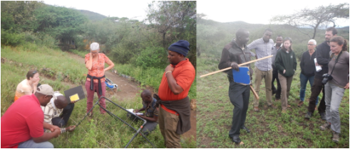
The final session focused on monitoring design, data entry and analysis. We briefly covered the current best practices for monitoring design and set up, looked at the various types of data entry, and the tools being developed by ACP and SORALO to automatically generate indicators and reports based on the field data. Although this session was brief, a good discussion was had, which focused on what was needed to make this information more useful to communities – for better decision making and for land-use planning. Although this was just the initial stages of discussions, a further workshop is scheduled for the middle of the year, to focus on how we can integrate data at a landscape level, and provide easy and simple tools to produce indicators and outputs for communities and NGOs.
In the coming months several of the Tanzania partners will begin the first steps towards implementing their ecosystem monitoring, with the first ten Tanzanian plots capturing rangeland information over 250 square kilometers . This data will provide invaluable for the local community, and for the much larger Kenya – Tanzania Borderlands area – where ecological monitoring is rapidly spreading to create a large network of information on the pastoral landscape.
On April the 5th a mixed team of community resource assessors (RAs) and research staff travelled down to Arusha to provide training on community based ecosystem monitoring. The training was conducted by staff from the South Rift Association of Landowners (SORALO) and the Amboseli Conservation Program (ACP). The trainees were made up of several NGOs working within the rangelands of Northern Tanzania. Representatives from Oikos, Northern Tanzanian Rangeland Initiative (NTRI) and Tanzanian People and Wildlife (TPW) attended. One trainee Resource Assessor from Mkuru village was also present, but otherwise the attendees were staff who would supervise and train RAs across the wider landscape. This training event followed on from the previous training provided by ACC and ACP in August 2015, with more focus on hands on skill for vegetation data collection.
The training took place over the course of Monday afternoon and Tuesday morning. The main emphasis of the sessions was to give hands on practical advice to those staff that will be responsible for supervising and collecting data in the field. We covered several different methodologies including the pin-frame (used by SORALO), the height times cover methods (used by ACP), and briefly went over techniques for species composition analysis. The attendees were also introduced to method used for point counts, which collect information that is used for understanding the spatial and temporal changes in wildlife and livestock numbers across the region.
The final session focused on monitoring design, data entry and analysis. We briefly covered the current best practices for monitoring design and set up, looked at the various types of data entry, and the tools being developed by ACP and SORALO to automatically generate indicators and reports based on the field data. Although this session was brief, a good discussion was had, which focused on what was needed to make this information more useful to communities – for better decision making and for land-use planning. Although this was just the initial stages of discussions, a further workshop is scheduled for the middle of the year, to focus on how we can integrate data at a landscape level, and provide easy and simple tools to produce indicators and outputs for communities and NGOs.
In the coming months several of the Tanzania partners will begin the first steps towards implementing their ecosystem monitoring, with the first ten Tanzanian plots capturing rangeland information over 250 square kilometers . This data will provide invaluable for the local community, and for the much larger Kenya – Tanzania Borderlands area – where ecological monitoring is rapidly spreading to create a large network of information on the pastoral landscape.